Designing a flood early warning system (FEWS) for West Africa

The great West African drought that started in the 1970s was undoubtedly a turning point in the region’s environmental discourse. It is well recognised as one of the most significant climate-driven disasters in recent history. The event was the onset of an era of rainfall uncertainty and variability, driving recurring floods and droughts across the region.

West Africa, an agglomeration of 16 countries, spans from the dense humid forests of the south to northern Saharan desertscapes (Figure.1). The region’s rainfall cycle is controlled by the Intertropical Convergence Zone. Changes in rainfall patterns have been attributed to climate change as well as land-use changes. ‘The Sahelian paradox’, is the increase in river flows despite reducing rainfall seen in many river basins. The complexity of hydrological and regional wind systems make it difficult to accurately predict long-term rainfall trends and their consequences.

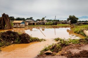
The Economic Community of West African States (ECOWAS) has invested significantly in drought management in the past. However, these nations have been unprepared for the sudden rise in floods over the last decade. In 2020, a year of particular flood severity, 198,000 homes were destroyed or damaged, 96,000 people were displaced and 2.2 million people were affected across West and Central Africa. If no action is taken, an estimated 32 million people will be forced to migrate internally by 2050.

In response to increasingly frequent disasters, many early warning systems for floods have been launched in West Africa. Flood early warning systems are typically designed around four broad considerations: knowledge of risks, monitoring and warning, response capacity and communication. These systems monitor real-time atmospheric conditions to predict weather conditions, and warn people and governments on how and when to act to minimise disaster impacts. Such tools are especially effective when emergency action plans are laid out and agreed upon by different stakeholders.

Existing flood early warning systems (FEWS) have not been able to meet stakeholders’ needs regarding timeliness of information, geographical coverage, uninterrupted communication, accuracy and open ownership. To increase the adoption, effectiveness and usefulness of warning systems, stakeholder engagement in the design phase is crucial. Generally, empirical evidence on the effectiveness of participatory processes in sustainability science and disaster planning has been weak.

The EU Horizon 2020 FANFAR (Reinforced cooperation to provide operational flood forecasting and alerts in West Africa) project aimed to change this. Within FANFAR’s broader aim of developing a FEWS, our research focused on designing such a system in collaboration with 50-60 stakeholders from 17 countries. Stakeholders included emergency managers, representatives from regional and national hydrological services and river basin institutions. Two key participating organisations were the West African consortium members AGRHYMET Regional Center and the Nigeria Hydrological Services Agency.

We used a research approach called Multi-Criteria Decision Analysis (MCDA). MCDA helps find possible solutions in situations where multiple, often conflicting, criteria need to be considered when assessing options. The first research question investigated what a good FEWS looks like in the West African context.

The second and broader objective explored the relevance of using MCDA as a participatory and transdisciplinary approach for a large project potentially benefiting millions of people across several countries. The participatory process was designed around three key project phases and implemented through a series of stakeholder workshops (Figure 2).

During the first phase of co-designing, stakeholders developed a joint understanding of the problems of existing flood warning systems. They came to a consensus on objectives that were needed to prioritise functions in the warning system. The second phase focused on knowledge co-production, where scientific and societal perspectives and practitioners’ expertise from different sectors were integrated.

The aim of MCDA was to design a FEWS in a way that best meets the objectives and preferences of all stakeholders. During the final stage of co-dissemination and evaluation, the aim was to translate the knowledge produced into solution-oriented and scalable products.

From the co-designing phase, ten objectives emerged as fundamentally important to stakeholders, clustered into four groups. These were clarity and accuracy of information, reliable and timely information access, affordability of production development and operation, and long-term financial and operational sustainability of the early warning system (Figure 4). The ten objectives received different weights depending on their importance to stakeholders.

Of the eleven versions of FEWS that were created by stakeholders and the FANFAR consortium, three were assessed to be well-performing and robust. One version, for example, could function with relatively minimal resources such as poor internet connectivity, unstable power supply and a limited number of skilled personnel. It suggests the FEWS should be simple and robust rather than incorporating many complex features.

MCDA was particularly helpful in focusing on stakeholders’ values. It helped in navigating and reconciling conflicting stakeholder preferences. MCDA was also helpful for knowledge co-production by providing clarity on stakeholder preferences, incorporating diverse perspectives from different disciplines and assessing different FEWS versions despite uncertain data.

The uptake of the FANFAR FEWS in West Africa will depend on a multitude of other factors. These include operational data collection, strategies to increase local capacity, securing long-term funding for operations, maintenance, and technical development. Local and regional governance structures also play an important role. However, because it was built on a common understanding of contextual challenges among diverse stakeholders, we believe the resultant FEWS will be useful to stakeholders from different regions, sectors and professional backgrounds.


[Source: Lienert, J. et al. (2022) 'How to co-design a flood early warning system (FEWS) for West Africa' Water Science Policy, doi: https://dx.doi.org/10.53014/CBJJ5560]

Study uses AI to predict fragility of power grid networks - double trouble when 2 disasters strike electrical transmission infrastructure

One disaster can knock out electric service to millions. A new study suggests that back-to-back disasters could cause catastrophic damage, but the research also identifies new ways to monitor and maintain power grids.

Researchers at The Ohio State University have developed a machine learning model for predicting how susceptible overhead transmission lines are to damage when natural hazards like hurricanes or earthquakes happen in quick succession.

An essential facet of modern infrastructure, steel transmission towers help send electricity across long distances by keeping overhead power lines far off the ground. After severe damage, failures in these systems can disrupt networks across affected communities, taking anywhere from a few weeks to months to fix.

The study, published in the journal Earthquake Engineering and Structural Dynamics, uses simulations to analyze what effect prior damage has on the performance of these towers once a second hazard strikes. Their findings suggest that previous damage has a considerable impact on the fragility and reliability of these networks if it can’t be repaired before the second hazard hits, said Abdollah Shafieezadeh, co-author of the study and an associate professor of civil, environmental and geodetic engineering.

“Our work aims to answer if it’s possible to design and manage systems in a way that not only minimizes their initial damage but enables them to recover faster,” said Shafieezadeh.

The machine learning model not only found that a combination of an earthquake and hurricane could be particularly devastating to the electrical grid, but that the order of the disasters may make a difference. The researchers found that the probability of a tower collapse is much higher in the event of an earthquake followed by a hurricane than the probability of failure when the hurricane comes first and is followed by an earthquake.

That means while communities would certainly suffer some setbacks in the event that a hurricane precedes an earthquake, a situation wherein an earthquake precedes a hurricane could devastate a region’s power grid. Such conclusions are why Shafieezadeh’s research has large implications for disaster recovery efforts.

“When large-scale power grid systems are spread over large geographic areas, it’s not possible to carefully inspect every inch of them very carefully,” said Shafieezadeh. ”Predictive models can help engineers or organizations see which towers have the greatest probability of failure and quickly move to improve those issues in the field.”

After training the model for numerous scenarios, the team created “fragility models” that tested how the structures would hold up under different characteristics and intensities of natural threats. With the help of these simulations, researchers concluded that tower failures due to a single hazardous event were vastly different from the pattern of failures caused by multi-hazard events. The study noted that many of these failings occurred in the leg elements of the structure, a segment of the tower that helps bolt the structure to the ground and prevents collapse.

Overall, Shafieezadeh said his research shows a need to focus on re-evaluating the entire design philosophy of these networks. Yet to accomplish such a task, much more support from utilities and government agencies is needed.

“Our work would be greatly beneficial in creating new infrastructure regulations in the field,” Shafieezadeh said. “This along with our other research shows that we can substantially improve the entire system’s performance with the same amount of resources that we spend today, just by optimizing their allocation.”

This work was supported by the Korea Institute of Energy Technology Evaluation and Planning (KETEP) and the Ministry of Trade, Industry & Energy of the Republic of Korea (MOTIE).

WMO issues guidelines on coastal flooding early warning systems

New WMO Guidelines on the Implementation of a Coastal Inundation Forecasting Early Warning System offer solid and practical advice for countries, donors and experts seeking to set up early warning systems against an increasing hazard.

The guidelines are a contribution to the UN Early Warnings for All initiative and reflect the high priority needs of small island developing States (SIDS) and Least Developed Countries that are particularly vulnerable to these coastal hazards.

“The severity of the impacts of disasters, especially on coastal communities, is well known and documented. A contributing factor is the increasing intensity and frequency of meteorological and oceanographical hazards caused by climate change, including sea-level rise, which can seriously affect SIDS and other coastal nations,” state the guidelines.

“It is critical to recognize that coastal inundation can result from single or multiple hazards, and that it is being exacerbated by the impacts of climate change, especially associated with sea-level rise."

“Coastal inundation events are an increasing threat to the lives and livelihoods of people living in low-lying, populated coastal areas. Furthermore, the issues for most countries that have vulnerable coastlines are the increasing level of development for fishing, tourism and infrastructure, and the sustainability of their communities,” it says.

The new guidelines were presented during a side event during WMO’s Commission for Weather, Climate, Water and Related Environmental Services and Applications (SERCOM), attended by more than 140 participants from all over the globe, including the South Pacific, the Caribbean, and Africa.

WMO is grateful to the Climate Risk and Early Warning Systems Initiative and the Korean Meteorological Administration for financial support.

These guidelines are based on the successful implementation of demonstration systems in four countries between 2009 and 2019 through the Coastal Inundation Forecasting Demonstration Project, which included a special focus on Pacific islands. They also incorporate key principles of WMO's Flash Flood Guidance System (FFGS) and the Severe Weather Forecast Programme.

The aim is to be a “one-stop” shop that countries can follow to prepare and implement their own coastal inundation forecasting early warning system. It provides a straightforward 10 step process with templates featuring policy, management and technical processes that countries or regions can use to build their own early warning system, from vision through to “go-live” implementation. As such information is not always readily available in many countries, these guidelines have concentrated on these features in developing and building a system, including necessary information for sponsors and advice on the resources necessary for success.

The Guidelines are also a registered activity of the United Nations Decade of Ocean Science for Sustainable Development.

ASEAN Framework on anticipatory action in disaster management

The ASEAN Framework on Anticipatory Action in Disaster Management provides guidance for defining and contextualising anticipatory action at the regional level with some considerations for its implementation by Members of the Association of Southeast Asian Nations (ASEAN). This Framework outlines three building blocks of anticipatory action and proposes a Plan of Action for 2021–2025 with the primary aim to streamline anticipatory action in disaster risk management (DRM) through joint regional efforts. The implementation of the action plan will strengthen the ASEAN’s vision of building disaster-resilient nations and communities.

It aims to help advance implementation of anticipatory actions in the ASEAN region while supporting ASEAN in spearheading a common language, objectives and ambition for the global community working on anticipatory action. It represents a landmark commitment from ASEAN to move the anticipatory action agenda forward in the subregion in support of a climate-resilient future. It should be seen as a vehicle to accelerate regional policies and support ASEAN in implementing global frameworks, including the Sendai Framework for Disaster Risk Reduction, the Paris Agreement on Climate Change, and the Sustainable Development Goals (SDGs). An anticipatory approach can achieve these commitments by addressing the humanitarian–development nexus and gaps between disaster risk management and climate change adaptation, maximising climate science and disaster risk finance.