New open-source software that decrypts social media messages to help manage risks and disasters

The European Commission’s new algorithm developed by the Joint Research Centre (JRC) can segment social media messages to identify, verify and help manage disaster events -such as floods, fires or earthquakes- in real-time.

Suppose you are an emergency responder and you see a social media post showing an unusable road in a place not covered by traditional news. Suppose you see a similar message from several accounts. Wouldn’t you wonder if they were referring to the same event or whether that area was worth a more detailed analysis with a satellite image?

It was with this in mind that scientists from the JRC helped deal with the 2021 Haiti Earthquake by using social media data analysis to complement the assessment of impacts in the immediate aftermath of the earthquake.

This experience was the first real case usage of a software platform that can scan millions of social media texts and images per day for situational awareness and impact assessment. This information is collected, filtered and geocoded automatically and in real-time using machine learning (artificial intelligence) models.
A software that helps responders with flood risk management

The first goal of this platform was to provide an additional geospatial layer in the European Flood Awareness System (EFASSearch for available translations of the preceding linkEN•••) and the Global Flood Awareness System (GloFAS). These two online systems offer flood forecasts based on model simulations which are crucial to the Copernicus Emergency Management Services Managed by JRC.

The monitoring ability of these early warning systems is mostly anchored in satellite images and numerical models.The integration of this new social media for disaster risk management (SMDRM) software will allow them to assess the likelihood and impacts of a flood event with even greater accuracy.
An open-source tool available to all researchers and technicians

The new layer for EFASSearch for available translations of the preceding linkEN••• and GloFAS is the first product developed using the SMDRM software. Nonetheless, since the software has been released as open-source -free and open to all technicians linked to crisis response who want to leverage it- the scientists expect it to have a wider use and they remain available for collaboration.

The SMDRM software can be adapted for different scales and label relevant images for floods, storms, earthquakes and fires, resulting in valuable information for reports or descriptions of the situation on the ground or in the vicinity.

Technicians or researchers working on map development can use the code to find more data to improve or confirm their findings and complement information extracted from traditional sensors or earth observation sources.
Software that connects citizens to disaster risk management

The SMDRM software data help confirm whether an event is happening and where exactly the most affected locations are.

It is a clear example of how social media and active citizenship can contribute to disaster risk management as it help crisis responders improve their situational awareness in the immediate aftermath of an event.

DOE Should Address Lessons Learned from Previous Disasters to Enhance Resilience

Natural disasters, such as cyclones, earthquakes, hurricanes, wildfires, and severe storms—and the power outages resulting from these disasters—have affected millions of customers and cost billions of dollars. The growing severity of wildfires and extreme weather events in recent years has been a principal contributor to an increase in the frequency and duration of power outages in the U.S. Federal agencies, such as DOE and the Federal Emergency Management Agency, play a significant role in disaster response, recovery, and resilience.

This report (1) identifies lessons learned from federal, state, and other entities' responses to selected disasters that affected the electricity grid from 2017 to 2021; and (2) examines federal agency actions to address those lessons learned. GAO selected a nongeneralizable sample of 15 of 35 disasters that affected the grid from 2017 to 2021. The 15 selected were among the most severe events across a range of types, locations, and years. GAO also examined agency and industry responses; reviewed relevant reports, policies, and documents; and interviewed federal, state, and local officials, as well as selected industry stakeholders.

Power outages caused by natural disasters have affected millions of customers and cost billions of dollars. The Department of Energy plays a key role in disaster response and long-term electricity grid recovery.

DOE has taken some steps to improve its workforce and training, tools and technology, and local capacity to respond to disasters. But, DOE doesn't have a comprehensive plan for coordinating response and recovery responsibilities within the agency. In addition, DOE hasn't used lessons learned from previous disasters to prioritize recovery efforts.

In responding to selected disasters occurring between 2017 and 2021, federal, state, and other stakeholders identified lessons learned in the areas of planning and coordination, workforce and training, tools and technology, and local capacity. In the area of planning and coordination, agency officials and reports highlighted that disaster responses were more effective when strong working relationships existed between federal, industry, and local stakeholders. Regarding workforce and training, a Department of Energy (DOE) report emphasized the importance of having a dedicated pool of responders with expertise in grid reconstruction and recovery, especially when responding to multiple, concurrent or successive disasters.

Federal agencies have taken steps to address lessons learned by improving workforce and training, tools and technology, and local capacity. For example, to address workforce lessons, DOE began deploying a Catastrophic Incident Response Team to quickly bring responders with subject-matter expertise to affected areas. However, DOE does not have a comprehensive approach for coordinating its broader grid support mission that includes disaster response, grid recovery, and technical assistance efforts. Specifically, roles and responsibilities within DOE for transitioning from response to recovery are unclear, as are how lessons learned from previous disasters are used to prioritize recovery and technical assistance efforts. GAO's Disaster Resilience Framework states that bringing together the disparate missions and resources that support disaster risk reduction can help build resilience to natural hazards. By establishing a comprehensive approach that clearly defines roles and responsibilities, and acting on lessons learned across DOE, the department could better target resources and technical assistance. This approach, in turn, can lead to enhanced grid resilience and reduced disaster risk.


Investing in resilient infrastructure for a better future

Day-to-day life depends on infrastructure and its services, this includes supply-chains, electricity, water and sanitation, and information networks. But in the face of the COVID-19 pandemic and increasing extreme weather events, these systems are under increasing threat.

A single event in December 2020, Cyclone Yasa, caused around USD 1.4 billion in damage to health facilities, homes, schools and other critical infrastructure in the Pacific island nation of Fiji. Beyond the economic toll, there was immeasurable disruption to people’s lives as a result of downed systems, extending the duration of the disaster beyond the passing of the cyclone.
Vital services for people and communities

Measuring the resilience of infrastructure is a challenge: There is no common understanding of what “resilient infrastructure” means, nor agreed benchmarks against which to gauge infrastructure resilience. Infrastructure is commonly understood as comprising assets and buildings; this needs to shift to include the vital services they provide.

“Social resilience touches on the capacity for a community to adapt, a resilient community is able to respond to changes, post-stress, in a positive way,” said Esther Anyakun Davinia, Uganda’s Minister of State for Relief, Disaster Preparedness and Refugees, speaking at a 7th Global Platform for Disaster Risk Reduction session titled, ‘Building a better future: Investing in resilient infrastructure for all’.

Moving towards net resilience gain

The Principles for Resilient Infrastructure – developed by the United Nations Office for Disaster Risk Reduction (UNDRR) to support the implementation of the Sendai Framework and the Sustainable Development Goals (SDGs) – describe a set of principles, key actions, and guidelines to create national-scale net resilience gain, and improve the continuity of critical services.

“We need a framework – such as we have for net zero," said panellist Rob Wesseling, CEO of The Co-operators Group, a Canadian insurance company. “There were no net-zero alliances not too long ago. There is already an excess of $130 trillion committed to various aspects of net zero which can be used to improve resiliency.”

Investing in sound infrastructure, Wesseling argued, would pay out in resilience dividends.

The net resilience gain approach requires that infrastructure investments enhance resilience and not create any additional risks.

The six interconnected Principles are designed to guide infrastructure stakeholders and leaders in building infrastructure resilience, calling for a process that is continuously learning, proactively protected, environmentally integrated, socially engaged, adaptively transforming, and based on shared responsibility.

The implementation process itself will give users a better understanding of their existing infrastructure systems: their performance, exposure, regulatory environment, challenges and barriers, as well as offering entry points for better risk-informed decision making and investments.

“Short cuts lead to greater costs, so maintenance needs to be integrated,” said Dena Assaf, United Nations Resident Coordinator for the United Arab Emirates. “How the infrastructure systems are maintained and integrated must be informed by the Principles for Resilient Infrastructure.”
A stress test to measure policy impacts on infrastructure resilience
“Infrastructure stress testing helps governments and stakeholders to base policy decisions and investments on factual and up-to-date information on the status of the resilience of infrastructure systems."
- Beata Janowczyk

Regulations that govern critical infrastructure also need strengthening. Governments must revisit their mechanisms and practices to evaluate whether they can cope with increasing requirements brought about by climate change, shifting demographic and development patterns, and other stresses.

Understanding the risk landscape – and its potential impacts on public finances – provides a good basis for realistic assessments of the costs and benefits of financing and policy options.

UNDRR’s recently developed Resilient Infrastructure Stress Test helps policymakers to see how policy changes could impact critical infrastructure, exposing major gaps to be prioritized. The stress test measures infrastructure performance against various stressors, and offers an assessment to provide specific policy recommendations.

“Infrastructure stress testing helps governments and stakeholders to base policy decisions and investments on factual and up-to-date information on the status of the resilience of infrastructure systems,” said Beata Janowczyk, head of the Risk Assessment and Emergency Planning Unit in Poland’s Centre for Security.

With significant recovery funding investments being made in new infrastructure, risk reduction and resilience must be central considerations shaping how and where these resources are spent.

Breaking silos to build resilience – Multi-hazard, multi-sectoral approaches to managing disaster risks

Disasters unfold across national boundaries, involving a range of interrelated hazards and complex dynamics. To tackle disaster risks and build resilience in the face of increasing climate-related disasters, it will require a united effort to move beyond working in silos.

“Member states, the UN system, governments – whether national, local or community-level governments – will need to learn more and more how to work in an interdisciplinary manner,” said David Smith, coordinator of the Institute for Sustainable Development at the University of the West Indies, and moderator of the session Breaking the Silos – Towards multi-hazard, multi-sectoral approaches to managing risks at the 7th Global Platform for Disaster Risk Reduction.

“One ASEAN, one response”

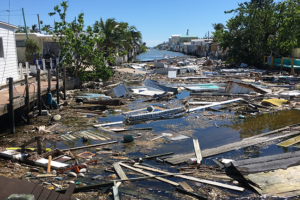
Southeast Asia and the Pacific region are especially affected by natural hazards, and in recent years has been the site of numerous disasters – cyclones, floods, tsunami and seismic events, compounded by the COVID-19 pandemic. Susana Juangco, Director of the Philippines Office of Civil Defense, explained how ASEAN, the Association of Southeast Asian Nations, has taken steps towards better coordination in its disaster risk reduction (DRR) strategies.

“The disaster risk landscape is becoming more complex and challenging,” she said. “There is a need to strengthen and broaden cooperation, not only within the ASEAN region but also externally, including with non-traditional partners.”

One example is the ASEAN Joint Taskforce on Humanitarian Assistance, which draws in expertise from many sectors – political, defence, health, social welfare and development.

“Disaster management should be everyone’s business,” she said, “Instead of working in silos, inter-operativeness and coordination should be the essence of all our DRR initiatives.”
Understanding risk from community viewpoints

Bijay Kumar, Executive Director of the Global Network of Civil Society Organisations for Disaster Reduction (GNDR) described how an inclusive, community-based approach can strengthen DRR and resilience building by drawing on local perspectives.

“As a global network… we are trying to see how risks are understood from the perspective of the people experiencing them.”

A GNDR programme has examined how communities have been included in various governance systems, and how this inclusion has changed over a ten-year period, drawing on the experiences of representative samples of communities across 48 countries worldwide.

In Indonesia, for example, the study found that a consultative process helped to activate a penta-helix approach involving local governments, civil society, academia and the media in developing plans which were then taken up at a national level.

“It is possible to bring a comprehensive analysis to inform a sustainable way of building resilience,” he noted.

Finding the right tools for the job

Scientists have a range of tools at their disposal for assessing disaster risk. There are well-established methods for assessing primary impacts from external shocks, but in many of the places that experience disasters, data is often in short supply. However, when it comes to assessing systemic risks and the complex dynamics that cause wider impacts, there are fewer options.

Olaf Neußner, an independent expert for the German Committee for Disaster Reduction (DKKV) believes that recent global events – the pandemic and the war in Ukraine – could help to break down silos between different avenues of research, and create new opportunities for risk analysis.

“There is a lot of information available, and researchers can look into this and see what the cascading effects actually are,” he said.

In order to process the enormous volume of data, risk assessments could draw on machine learning and artificial intelligence to better understand causal relationships and connections between hazards and impacts.

Economic models could also be useful in understanding the socio-economic impacts of disasters – this requires that the two silos of economic and DRR analysis are bridged.
“Breaking silos takes time and energy, but it is worth it.”

Peter Binder, Director-General of MeteoSwiss and the Swiss Permanent Representative to the World Meteorological Organisation (WMO), offered examples of how DRR initiatives in Switzerland have deliberately set up structures to break down silos.

This entailed establishing the Steering Committee on Intervention in Natural Hazards, which brings together government and academic institutes dealing with weather, fire, civil protection, seismic events, avalanches and topography. The Committee operates on three hierarchical levels, each involving all of the parties.

A similar collaborative approach is applied by the National Centre for Climate Services, bringing together seven federal offices with academic institutions.

“Breaking silos takes time and energy, but it is worth it,” he said.

An earth system approach

At an international level, Binder noted that the WMO – with responsibility for weather, water and climate – provides another example of breaking silos.

“The three disciplines are intimately linked in nature and, therefore, should also be in our scientific and operational treatment,” he said. “This is the earth system approach, indispensable for managing multi-hazard risk.”

Switzerland is promoting an initiative to take this further, to bolster global preparedness for natural hazards.

Under the WMO Coordination Mechanism, “all available authoritative information on meteorological and hydrological threats from WMO members should be directed into the information channels of the pertinent UN and humanitarian aid organisations. This constitutes a multi-organizational and multinational effort to mitigate risk related to meteorological, hydrological and climate hazards,” he said.

[Source: UNDRR]

Disaster Resilience: Opportunities to Improve National Preparedness

Each year, disasters such as hurricanes and wildfires affect hundreds of American communities. The federal government provides billions of dollars to individuals and communities that have suffered damages. According to the U.S. Global Change Research Program, extreme weather events are projected to become more frequent and intense in parts of the U.S. as a result of changes in the climate. Investments in disaster resilience can reduce the overall impact of future disasters and costs.

This testimony discusses GAO reports issued from 2015 through 2021 on disaster preparedness and resilience. This includes FEMA's National Preparedness System and associated grants; hazard mitigation grant programs; and GAO's Disaster Resilience Framework for identifying opportunities to enhance resilience. The statement also describes actions taken to address GAO's prior recommendations through March 2022.

GAO has evaluated federal efforts to strengthen national preparedness and resilience and identified opportunities for improvement in several key areas:

FEMA Efforts to Strengthen National Preparedness. The Federal Emergency Management Agency (FEMA)—the lead agency for disaster preparedness, response, and recovery—assesses the nation's emergency management capabilities and provides grants to help state, local, tribal, and territorial governments address capability gaps. In May 2020, GAO found that FEMA and jurisdictions have identified emergency management capability gaps in key areas such and recovery and mitigation. GAO recommended that FEMA determine steps needed to address these capability gaps. FEMA agreed and plans to develop an investment strategy that aligns resources with capability gaps.

FEMA's Hazard Mitigation Grant Programs. In February 2021, GAO found that state and local officials faced challenges with FEMA's hazard mitigation grant programs. Specifically, officials GAO interviewed from 10 of 12 selected jurisdictions said grant application processes were complex and lengthy. This could discourage investment in projects that would enhance disaster resilience. FEMA officials said they intended to identify opportunities to streamline, but did not have a plan for doing so. GAO recommended that FEMA develop such a plan. FEMA agreed and is in the process of doing so.

Identifying Opportunities to Enhance Disaster Resilience. In October 2019, GAO issued a framework to guide analysis of federal actions to promote resilience to natural disasters and changes in the climate. For example, the framework can help identify options to address government-wide challenges that are of a scale and scope not addressed by existing programs.

FEMA Resources for Climate Resilience

As climate change increases disaster risks across the country, emergency managers and government officials are beginning to implement strategies to build community resilience. FEMA Resources for Climate Resilience provides a roadmap of Federal Emergency Management Agency (FEMA) programs and initiatives that advance community climate resilience. FEMA Resources for Climate Resilience assists FEMA’s state, local, tribal, and territorial (SLTT) partners in navigating the FEMA resources that are available to support communities in mitigating impacts of climate change.

Building resilience is a long-term, ongoing cycle that requires multiple steps to accomplish. Each section of the FEMA Resources for Climate Resilience corresponds with a step in that cycle and provides information about FEMA services, programs, and grants available to SLTT partners. Each SLTT partner has a unique experience with FEMA and has participated in different elements of the resilience cycle. SLTT partners with limited FEMA experience may choose to start from the beginning of FEMA Resources for Climate Resilience, while other SLTT partners may navigate directly to their program of choice.

Each section of FEMA Resources for Climate Resilience provides a brief description of the program, service, or grant, an overview of who can apply, examples of the FEMA programs in action, and helpful tools and resources for learning more about the program, service, or grant. In addition, where applicable, FEMA Resources for Climate Resilience also points out areas where equity can be prioritized. FEMA Resources for Climate Resilience explains how existing tools, such as the National Risk Index (Risk Index), can assist SLTT governments and their communities, right now, in making informed planning decisions including considerations of impacts from future weather conditions.

FEMA Resources for Climate Resilience also provides a quick glance at FEMA funding sources, such as the Building Resilient Infrastructure and Communities (BRIC) program, designed to support communities in building capability and capacity to mitigate the increasing impacts of climate change.

FEMA Resources for Climate Resilience is available to download at https://www.fema.gov/sites/default/files/documents/fema_resources-climate-resilience.pdf

UNDRR ROAMC: How disaster preparedness makes the difference when disaster hits

When COVID began to infiltrate the Caribbean, the World Food Programme (WFP) quickly contacted governments to find how to best help funnel cash to people left struggling to feed their families as jobs began to melt away.

For Dominica, helping rapidly digitalize the country's largely paper-based data collection and payment systems was the speediest and most effective solution, says Regis Chapman, head of office for WFP in Barbados.

Within weeks, WFP helped Dominica implement systems to more efficiently collect and analyze the data needed to determine who was eligible for payments to help ride out the pandemic.

By printing scannable QR codes on payment envelopes and asking people to sign digitally to confirm receipt, Dominica quickly created a visualization dashboard to show where and when funds were distributed.

“We're now looking at developing an information management system to better manage data on all their social protection programs, not just the public assistance program," says Chapman.

“The socio-economic aspect of COVID has been devastating. The lowest income groups are the people who are most affected and we’ve seen huge spikes in food insecurity.”

WFP’s shock responsive social protection program is one of the many in the Caribbean supported by the European Commission Humanitarian Aid Office (ECHO) which has provided $183 million in aid to the region - excluding Haiti - since 1994.

Through its DIPECHO disaster preparedness program, $50 million of those funds have targeted disaster risk reduction and community resilience programs.

Now as middle-income Caribbean countries compete with other parts of the world for increasingly tight donor funding, it is more important than ever to show how projects support communities and protect lives and livelihoods, say experts.

BLUEPRINTS

Presenting evidence of successful schemes also helps create templates that can be used in other parts of the world, says Saskia Carusi, external relations officer for the United Nations Office for Disaster Risk Reduction, Regional Office for the Americas and the Caribbean (UNDRR).

“It’s important to show how successful projects are from an accountability point of view," says Panama-based Carusi.

"But for ECHO, it’s important to show evidence that projects save lives and make a difference, and that there are still needs in the region."

The best evidence should be a combination of quantitative data showing how losses are reduced by disaster risk reduction projects, alongside qualitative examples of how schemes work on the ground, says Carusi.

Evidence should also examine whether localized, pilot projects can be rolled out in neighboring communities or even scaled up to a national level, she says.

With EU funding, UNDRR has created the dipecholac.net platform where organizations can highlight their Caribbean projects and show how they relate to the Sendai Framework for Disaster Risk Reduction 2015-2030.

It now wants organizations to upload videos, documents and infographics to the site that show how Caribbean projects have been adapted to make a difference during the pandemic and other emergencies.

For the International Federation of Red Cross and Red Crescent Societies (IFRC), the pandemic has underscored the importance of preparing Caribbean communities to deal with multiple hazards, says Marisa Clarke-Marshall, IFRC coordinator, partnerships and planning.

During the crisis, Community Disaster Response Teams (CDRTs) trained by the Red Cross with ECHO funding to deal with hazards such as hurricanes, have rapidly adapted to help communities cope with COVID, she says.

Trained primarily to conduct initial damage assessments, give first aid and coordinate immediate response, CDRTs have helped identify those most in need in their communities, and deliver cash vouchers and hygiene kits.

The CDRT project has attracted attention from major donors keen to set up similar teams elsewhere, while an ECHO-funded tool to assess risk and vulnerabilities is now used globally, she says.

HIGH-LEVEL IMPACT

Events such as November’s UNDRR co-organized VII Regional Platform for Disaster Risk Reduction in the Americas and the Caribbean provide an opportunity for both governments, multilaterals and non-profits to show which projects best helped tackle COVID while continuing to ramp up preparedness.

For UNDRR, its projects to boost Caribbean business resilience reaped dividends during the pandemic as companies adapted their continuity plans that were primarily designed to tackle climate-related crises, says Carusi.

Its EU-funded project to increase preparedness and disaster risk reduction through the Caribbean Safe Schools Initiative is now generating interest from other countries in Latin America, says Carusi.

"UNDRR’s work on policy and advocacy in the long run has a higher impact," says Carusi.

For WFP, EU funding is supporting its work with the Caribbean Disaster Emergency Agency (CDEMA) to pre-position generators, prefabricated units and other gear to help countries better prepare, save lives and reduce losses.

"A lot of what we're looking at is how do we help government systems to become more resilient," says Chapman.

"One of the region's prime ministers recently said, everybody says the Caribbean is so resilient, it's that we have to be. You have to stand up when you're knocked down and start all over again because what other choice do you have."

[Source: UNDRR]

Electricity Grid Resilience

The nation’s grid delivers electricity that is essential for modern life. However, the grid faces risks from events that can damage electrical infrastructure (such as power lines) and communications systems, resulting in power outages. These outages can threaten the nation’s economic and national security.

They can also disproportionately affect low-income groups, in part because such groups have fewer resources to invest in backup generators and other measures to minimize the impact of outages.Even though most of the electricity grid is owned and operated by private industry, the federal government plays a key role in enhancing grid resilience.
• The Department of Homeland Security (DHS) is responsible for coordinating the overall federal effort to promote the security and resilience of the nation’s critical infrastructure sectors.
• The Department of Energy (DOE) leads federal efforts to support electricity grid resilience, including research and technology development by national laboratories.
• The Federal Energy Regulatory Commission (FERC) reviews and approves standards developed by the North American Electric Reliability Corporation, the federally designated U.S. electric reliability organization.

Key Issues
The electricity grid faces multiple risks that can cause widespread power outages.
Risks:
- Extreme weather and climate change
- Cyber- and physical attacks
- Electromagnetic events

In addition to the risks described in the prior page, the electric utility industry faces complex challenges and transformations, including:
• aging infrastructure;
• adoption of new technologies, such as information and communication systems
to improve the grid’s efficiency; and
• a changing mix of power generation. The traditional model of large, centralized power generators is evolving as retiring generators are replaced with variable wind and solar generators, smaller and more flexible natural gas generators, and nontraditional resources. Such resources include demand-response activities which encourage consumers to reduce their demand for electricity when the cost to generate electricity are high, and various technologies (e.g., solar panels) that generate electricity at or near where it will be used—known as “distributed generation.”

Key Opportunities
Agencies have implemented several of GAO’s recommendations for improving electricity grid resilience. For example, in March 2016, we recommended that DHS designate roles and responsibilities within the department for addressing electromagnetic risks, which DHS did in 2017. However, as of September 2021, agencies had not yet implemented a number of GAO recommendations that represent key opportunities to mitigate risks in the following areas:

- Extreme weather and climate change - Prioritize efforts and target resources effectively. Enhance grid resilience efforts. Better manage climate-related risks
- Cyberattacks - Assess all cybersecurity risks. Address risks to distribution systems Consider changes to current standards. Evaluate potential risks of a coordinated attack

Early warning systems saving lives during Nepal’s monsoon

For days leading up to the disaster, Mr. Harisaran Shrestha had been listening to warnings about floods in the Melamchi, a river that flows through the foothills of the Himalayas in central Nepal. At least one local FM radio was repeatedly broadcasting notices about the possible release of water from the reservoir of a nearby drinking-water project and urging the public to avoid river banks and to refrain from activities like fishing, sand mining, and gravel collecting.

The local police and representatives were also issuing similar warnings around the town via microphones and loudspeakers.

Owing to these forewarnings, when the flood eventually hit his hometown, Melamchi Bazar, northeast of Kathmandu in Sindhupalchowk district, in June 2021, Mr. Shrestha was better prepared to react to the deluge. “As soon as it became apparent that the flood was going to sweep the entire town, I used my bus to ferry women, children, and disabled people in the neighbourhood to a safer location,” said Mr. Shrestha.

On June 15, just an hour after the final warning from the radio and police announcement on loudspeaker, massive floods near the confluence of the Melachmi River and the Indrawati River swept through the settlements near Shrestha’s hometown, killing at least five people and destroying property worth millions of rupees. At least a dozen people remain missing more than two months after one of the worst disasters in the town's history.

Despite saving many lives, Mr. Shrestha could not save his belongings because he had underestimated the scale of the disaster. “Our home was at a considerable distance from the river. It never occurred to me that the swollen river’s waters would reach this far,” Mr. Shrestha recalled in an interview.

Now displaced by the flood, Mr. Shrestha, 38, has been living with a family of six in a temporary shelter. The river, which has changed its course, now runs through his home and farmland.

“The river took everything. Thankfully, all of us are safe,” said Mr. Shrestha.

Mr. Dev Raj Subedi, the manager of Radio Melamchi, which issued the flood warnings, said that the alerts had proved effective in saving hundreds of lives, although only a few households managed to save some of their possessions--those they could carry with them. Radio Melamchi has been ritually providing flood-related warnings to the municipality’s estimated 50,000 inhabitants for the last few years, especially after the Melamchi Drinking Water Project gathered momentum in the 2010s.

“We issued the warning as soon as a government official informed us about the flood upstream. The warning proved especially helpful in the town area, whose inhabitants had the means to access the warning. That was one of the reasons there were no deaths in the town area,” shared Mr. Subedi.

Melamchi’s case is the latest example of how the growing use of mass media and early warning systems through data collected from meteorological and hydrological stations and rainfall-runoff model is proving effective in saving lives in Nepal, which is highly susceptible to disasters, owing to its topography and its hundreds of big and small rivers.

Every year, floods and landslides wreak havoc in Nepal, leading to huge numbers of casualties and untold destruction of property. Hill settlements are particularly vulnerable to landslides and flash floods, while riverine floods routinely deluge the lowland areas bordering India.

Every year during the rainy season, hundreds of families lose their house, agricultural yield, and means of livelihood, pushing them further into poverty.

Between 13 April to 16 October in 2020, floods and landslides killed at least 337 Nepalis, wiped out thousands of houses, and destroyed property worth billions of rupees, according to an estimate by Nepal’s Ministry of Home Affairs. More than 100 people remain missing on account of those floods.

Numerous factors including the 2015 earthquake, infrastructural projects and climate change have contributed to increasing disasters, according to experts. For instance, Sindhupalchowk district, the epicenter of the 7.8 magnitude earthquake that rattled Nepal in 2015, has seen a marked increase in landslides and floods following the tragedy that killed over 9,000 people.

Mr. Bikram Shrestha Zoowa, a senior Divisional Hydrologist at the Department of Hydrology and Meteorology, in Kathmandu, said that climate-induced hazards and unplanned development are emerging as challenges in recent decades.

Examples include recent disasters such as the Setigandaki flood in Kaski, Jure landslide-Sindhupalchowk in 2014, a Glacial Lake Outburst Flood (GLOF) in Tibet immediately above the Bhotekoshi River in Sindhupalchowk in 2016; a dry landslide in the Kaligandaki Corridor after the 2015 earthquake, another GLOF in Barun valley obstructing the flow of Arun River in 2017, and numerous climate-induced landslides during the 2020 monsoon and this year, said Mr. Shrestha Zoowa.

“Human interventions such as road construction in hill slopes without considering geological studies are certainly the causes of the region’s geological fragility, which results in small and big landslides in hilly regions. This is the man-made effect in addition to earthquakes responsible for hazards.”

According to the latest Intergovernmental Panel on Climate Change report, global temperature is expected to reach or exceed 1.5 degrees Celsius of warming averaged over the next 20 years. In 2019, a landmark report

by the International Centre for Integrated Mountain Development, an intergovernmental center based in Nepal, warned that a two-degree temperature rise could melt half of the glaciers in the Hindu Kush Himalaya region, destabilising Asia’s rivers.

In recent years, to minimise loss of life and property, an increasing number of communities vulnerable to disasters have begun to integrate social media platforms--such as Facebook and Twitter--and other technologies to provide early warnings. And as with Radio Melamchi, more than 500 FM radio stations across Nepal are being used to disseminate news and timely warnings. Many other local bodies are integrating SMS text messages to provide real-time alerts for people living in disaster-prone zones.

In Kailali, a western Nepal district bordering India’s Uttar Pradesh, flood warnings through SMS alerts and phone calls have proven effective in saving lives in settlements spread along the Karnali River Basin.

“When massive floods hit our village in 2016, most of the villagers with mobile phones had received SMS alerts three hours before the disaster. Those three hours gave us ample time to save not just our lives, but also our livestock and essentials like some grains and documents,” said Ms. Sajita Tharu of Laxmipur village in Kailali district. “Thankfully, we have not faced that kind of flood in recent years but we continue to receive alerts if water rises above the danger level. That allows us to remain mentally prepared and save essentials in case the flood hits us.”

As part of the community-based early warning approach, residents living in catchment areas constantly pass on information about the water level in their area to residents of villages downstream. The community groups also get constant flood alerts from the Department of Hydrology’s regional station. The alerts--including text messages, phone calls, and information from weatherboards--are widely circulated by the members of the Community Disaster Management Committees, which were formed by programs designed to enhance the communities’ flood resilience. Most members of these user committees are women, as many working-age men migrate to India or other countries in search of jobs.

Ms. Manakala Kumari Chaudhari, the deputy mayor of Rajapur Municipality in far-western Nepal, said that the timely early warning system in his area has been instrumental in saving lives and properties. As soon as the water level rises above the danger level upstream, several people who own mobile phones in his municipality--a delta created by the Karnali River--receive warnings.

“Save for some exceptions, most locals respond to warnings and take the required safety measures. The timely alerts also provide ample time for all stakeholders to make the necessary preparations for disasters,” said Ms. Chaudhari.

Such timely warnings are critical because they provide enough time to save lives. The area is susceptible to constant floods from big rivers like the Karnali and Babai and from small streams, which are usually dry in other seasons.

In preparation for the seasonal floods, communities in western Nepal have also built community shelters, animal sheds to shelter their livestock and grain-storage facilities to save grains.

Since Nepal adopted federalism in 2015, there have been efforts at all three levels of government to embrace disaster-resilience policies. The central government, the provincial government, as well as many local governments have adopted policies related to disaster risk reduction. Recently, under the Home Ministry, the National Disaster Risk Reduction and Management Authority prepared the National Monsoon Early Preparedness and Response Work Plan

2021. However, questions remain around the implementation of these policies and the authorities’ ability to handle large-scale disasters, especially owing to their lack of resources. Moreover, growing landslides along newly constructed highways, hydropower projects and other infrastructures-- many of which were cleared after proper Environment Impact Assessment--- have reinforced the need for better policies to promote resilient infrastructure.

But overall, the early warning systems seem to be reducing the impacts of floods in many parts of Nepal. Mr. Shrestha Zoowa, the hydrologist, said that early warning systems have proven effective in saving hundreds of lives every year, especially in vulnerable settlements along big rivers such as the Karnali, Babai, Narayani, and Koshi. The data gathered from weather stations, rainfall-runoff models are disseminated in form of daily bulletins through various media platforms, while the weather forecast relies on the Weather Research and Forecasting model, an advanced numerical weather prediction framework designed for operational forecasting and atmospheric research needs.

In recent years, the Department of Hydrology and Meteorology has been working with various non-governmental organizations in developing disaster information management systems and online databases to provide real-time information to augment its early warning systems.

The Disaster Risk Reduction Portal and Nepal Government GeoPortal, among other platforms, provide information gathered from various hydro-meteorological stations in Rasuwa, Solukhumbu, Kaski, Dolpa, Humla, Dolakha, Jumla, Sankhuwasabha and Manang districts.

“For most flood events, we have effective plans, technologies, and historical information to issue timely and reliable warnings to vulnerable settlements. But we lack an effective early warning system for flash floods in the hills and for settlements along small rivers, which are highly unpredictable,” said Mr. Shrestha Zoowa.

Nepal also needs to do more to ensure that people respond to early warnings. Although many local communities are making good use of weather forecasts and flood alerts, some are unable to take advantage of the information, often because they lack the economic means and/or technical knowledge to know what to do. Often the warning messages come with technical jargon and they may not effectively relay the impact information of the disaster relevant to people’s day to day life and experience. “The early warning systems have become much better over the years but there is still a lot to be done,” said Mr. Shrestha Zoowa.

Asia-Pacific needs to tackle overlapping crises

The Asia-Pacific region needs to step up efforts to prepare for and tackle complex, overlapping crises in order to increase the resilience of its people as well as its economies, with climate change threatening to dwarf the challenges of COVID-19 pandemic, a key meeting of the UN Economic and Social Commission for Asia and the Pacific has heard.

“Notwithstanding the progress made by many countries in devising more robust systems of early warning and responsive protection - with far fewer people dying as a result of natural disasters - the COVID-19 pandemic has demonstrated that almost without exception, countries around the world are still ill-prepared to deal with multiple overlapping crises, which often cascade,” said Armida Salsiah Alisjahbana, UN Under-Secretary-General and Executive Secretary of ESCAP.

“Tropical cyclones, for example, can lead to floods, which lead to disease, which exacerbates poverty,” she told the ESCAP Committee on Disaster Risk Reduction.

Since the start of the pandemic, the region has been hit by multiple natural and biological disasters. At the same time, climate change has continued to warm the world, exacerbating the impacts of many of these disasters. The Asia-Pacific Disaster Report 2021, which was launched during ESCAP’s Disaster Reslience Week, shows that the pandemic, combined with the persistent reality of climate change, has reshaped and expanded the disaster “riskscape” in Asia and the Pacific.

Resilience in Asia-PacificThe triple threat of disease, disaster and climate change is causing not only considerable human hardship but also significant economic losses. Currently, the annual average disaster-related losses are $780 billion. This could nearly double, to around $1.4 trillion, in a worst-case climate scenario. Choosing a proactive strategy of adapting to natural and other biological hazards would be far more cost-effective at an annual cost of $270 billion, said the report.

WMO Secretary-General Prof. Petteri Taalas urged great ambition to reduce greenhouse gas emissions and to accelerate climate change adaptation.

“If we fail with the climate change mitigation, the impact is going to be felt for centuries or even millennia, so the scale of the problem we are talking about when it comes to climate change, the scale is much bigger,” Prof. Taalas told ESCAP’s Committee on Disaster Risk Reduction.

The new report from the Intergovernmental Panel on Climate Change (IPCC) has highlighted the increasing severity of the physical impacts of climate change because of record concentrations of greenhouse gases. This includes long-term melting of glaciers, snow and ice cover, sea level rise and ocean acidification, which will last for centuries or even thousands of years, Prof. Taalas said in a video address.

“Heatwaves, drought, forest fires, flooding, landslides and tropical storms are becoming more intense, as a result. Last year was the warmest year on record in Asia and we have also seen record breaking flooding, especially in East Asia” Prof. Taalas said.

The ESCAP Committee on Disaster Risk Reduction is charged with addressing the following issues: (a) emergence of cascading risks and extension of the disaster risk-scape; (b) scaling-up multisectoral cooperation frameworks to manage cascading risks; and (c) status of regional co-operation efforts.

WMO was represented in several expert group meetings, panel discussions and side events. WMO and ESCAP have a Memorandum of Understanding to work together to build resilience to climate and disaster risks and the promotion of impact-based early warning services and systems. The two organizations have a long history of cooperation by jointly establishing the Typhoon Committee.

Prof. Taalas stressed the importance of building capacity in Least Developed Countries and Small Island Developing States to adapt to climate change and build resilience, in particular through investments in early warning services.

However, major gaps in observing systems in many parts of the world, including islands and least developed countries in the Asia-Pacific region, have a negative impact on the quality of early warning services. WMO’s new initiative, the Systematic Observations Financing Facility (SOFF) seeks to close these gaps and leverage sustainable financing.

1 2 3 4 5